
Voorbeelden navigatie-opdrachten
Benieuwd naar welk soort richtlijnen of vraagstukken je krijgt om onze checkpoints te vinden?
We geven hieronder alvast enkele mogelijkheden mee om te oefenen.
Standaard werken we voor onze opdrachten met topografische kaarten van het NGI (Nationaal Geografisch Instituut).
-
Reeks: Topo25
-
Schaal 1:25000
Zelf op stap gaan? Je kan deze kaarten steeds aankopen via de online webshop van het NGI
De kaarten tijdens onze activiteiten worden gegenereerd onder licentie toelating A4023 en mogen niet verder gereproduceerd worden. Niet-toegankelijke zones worden door ons gemarkeerd.

Multipoint & Point-2-Point
Bij een Multipoint en Point-2-Point opdracht ga je steeds aan de slag met 'navigatievraagstukken'. Door deze vraagstukken uit te werken op de kaart, kan je de locaties van de benodigde checkpunt aanduiden.
-
Bij een multipoint opdracht, krijg je alle vraagstukken tegelijk. Je berekent alle locaties, en gaat vervolgens de punten zoeken in een volgorde naar wens. Tactisch denken en het terrein goed inschatten dus!
-
Bij een Point-2-Point opdracht krijg je 1 vraagstuk tegelijk. Na het localiseren van het eerste punt, krijg je vervolgens de instructies naar het volgende punt, enzovoort. Zorg er dus voor
Enkele van de navigatie-aspecten die we hierin toepassen:
-
Hoekmeting
-
Afstandsmeting
-
Gebruik van vegetatie-zones, gebouwen, ...
-
Gebruik van wegen, paden, waterlopen, ...
-
Berekenen van UTM coördinaten
-
...
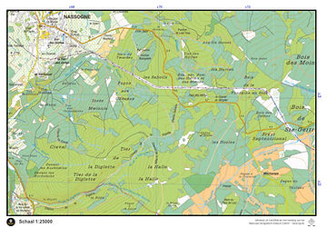
Voorbeelden Nassogne
Vraagstuk 1
Het checkpunt ligt op 3,6km in vogelvlucht tov van de middenstip van het voetbalveld in Nassogne. Vanuit
het checkpunt zie je deze middenstip (virtueel) liggen op 307°.
Vraagstuk 2
Het checkpunt ligt op een pad, pal onder de hoogspanningslijn, tussen de 30ste en 31ste hoogspanningsmast die je op je kaart kunt tellen, vanuit het oosten geteld.
Vraagstuk 3
Het checkpunt ligt aan een herdenkings-monument op 400m van km-paal 7 op de secundaire weg N889 vanuit Nassogne, en op 2,22m van km-paal 4 op diezelfde weg.
Vraagstuk 4
Het checkpunt ligt op een weg met losse verharding (grindweg), binnen loofbos gebied, op 5554,7m boven de evenaar. Ten oosten van het Basecamp. Op de kruising met een waterloop.
Voorbeelden Brugse Ommeland
Vraagstuk 1
Punt 1 is eenvoudig te bereiken wanneer je de begraafplaats van Waardamme weet te vinden. Van hieruit volg je de waterlopen in NW-richting via paden die niet op de kaart staan… Punt N zelf ligt 10m hoog en op 100m van kilometerpaal 94 van de N50
Vraagstuk 2
Punt 2 ligt op een kruising van 2 aardewegen met bomenrij en grenst aan naaldbos, loofbos, grasland en permanent grasland in Kampveld. Het ligt 5663,78km boven de evenaar.
Vraagstuk 3
Punt 3 ligt op een aardeweg in loofbosgebied. Op 2,125km van
de kapel O.L.V. van Lourdes, en op 1,65km van kasteel Les
Croisilles.
Vraagstuk 4
Punt 4 ligt aan een brugje over de Waardammebeek. Het brugje staat niet op jullie kaart, maar we kunnen wel meegeven dat je het brugje kan zien vanuit de kerk van Oostkamp op 161°

Route
Bij een Route opdracht, krijg je een (stuk van de) kaart mee waarin reeds een uitgestippelde route is ingetekend. Je neemt deze kaart mee en volgt deze route zo exact mogelijk na, om de nodige checkpoints 'ergens' onderweg tegen te komen. Goed kijken dus!

Snake
Bij een Snake opdracht geven we jou enkel 1 zichtbare, navigeerbare route mee. De rest van de kaart wordt volledig bedekt. Met deze beperkte context leg je de route af tot op het einde. Maak gebruik van iedere kleine aanwijzing, zoals kruispunten en vegetatiezones rondom je.

.jpg)
Oro-Hydro
Een Oro-Hydro kaart geeft jou enkel informatie mee omtrent hoogte (hoogtelijnen) en water (beekjes, rivieren, meertjes, ...). Een enorme uitdaging waarin je zeer aandachtig het terrein moet leren inschatten.Afhankelijk van de omgeving en moelijkheidsgraad, geven we jou een topokaart mee om de punten te localiseren.


Instructions
Bij een Instructions opdracht krijg je een hele reeks opeenvolgende loopinstructies mee. Je krijgt hiervoor ook de nodige topokaart mee. Volg iedere instructie exact op, en we leiden jou langs mooie plekjes en belangrijke checkpunten. Niet enkel navigeren dus, ook goed rondkijken!

Voorbeeld:
-
Ga het pad in dat vertrekt in richting 203°.
-
Blijf dit pad volgen, tot je een fietsroute (ravel) oversteekt. Steek deze fietsroute over.
-
Sla meteen daarna linksaf op een pad dat parallel loopt met dit fietspad en volg het gedurende 750m.
-
Sla rechtsaf in richting 243°.
-
Het pad gaat voorbij moerasgebied en een bomenrij. Ongeveer 10m voor de verharde weg, sla je rechtsaf.
-
Na 185m sla je af in het pad dat vertrekt richting het Westen.
-
Blijf dit pad volgen (het buigt rechtsaf richting het Noorden) tot voorbij de fietsroute.
-
±500m voor (zuidelijk van) de overgang naar een weg met losse verharding (grindweg) is er een pad dat afslaat naar rechts. Volg dit pad, tot je terug op de grote, brede aardeweg uitkomt.
-
Loop nu in richting 104°, terug tot aan het checkpunt waar je deze instructions-opdracht gestart bent.
Satellite
Bij een Satellite opdracht bezorgen we jou (stukjes van) een luchtfoto van de omgeving waarop enkele checkpoints aangeduid staan. Je kan deze checkpoints gaan zoeken ahv de zichtbare elementen op het satellietbeeld. Afhankelijk van de omgeving en moelijkheidsgraad, geven we jou een topokaart mee om de punten te localiseren.


Fishbone
Bij een Fishbone opdracht ...
Maak een kennis of familielid blij. Schenk een deelname aan 1 van onze activiteiten
Ondersteun onze werking. Zorg mee voor een goede omkadering voor onze deelnemers