
Examples of assignments
Curious about what kind of guidelines or assignments you will be given to find our checkpoints?
We provide some opportunities below for you to practice.
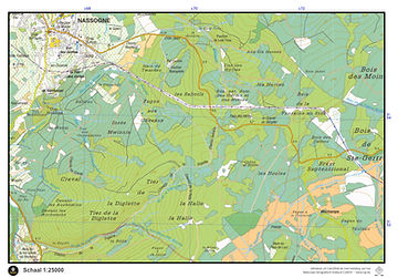
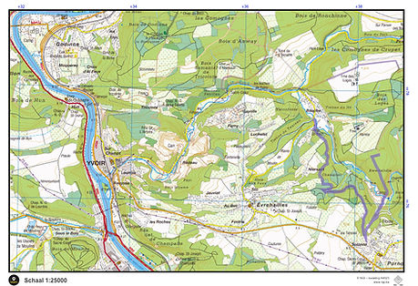
As standard practice, we use topographic maps from the NGI (National Geographic Institute) for our assignments.
-
Series: Topo25
-
Scale 1:25000
Going out on your own? You can always purchase these maps via the NGI online webshop.
The maps used during our activities are generated under license authorization A4023 and may not be reproduced further. Inaccessible zones are marked by us.

Multipoint & Point-2-Point
In a Multipoint and Point-2-Point assignment, you will always work on 'navigation problems'. By working out these problems on the map, you can indicate the locations of the required checkpoints.
-
In a multipoint assignment, you receive all problems at once. You calculate all locations and then search for the points in an order of your choice. So, tactical thinking and accurately assessing the terrain are required!
-
In a Point-2-Point assignment, you receive one problem at a time. After locating the first point, you will then receive instructions for the next point, and so on. So make sure
Some of the navigation aspects we apply during these assignments:
-
Angle measurement
-
Distance measurement
-
Use of vegetation zones, buildings, ...
-
Use of roads, paths, watercourses, ...
-
Calculation of UTM coordinates
-
...
Examples Nassogne
Checkpoint 1
The checkpoint is located next to a play area. 3.1 km from the church of Sint-Joris-Weert. You can see this play area from the church at 276°
Checkpoint 2
The checkpoint is located at a gate, near a lake, at coordinate UTM 31U 061558 562769
Checkpoint 3
We are looking for a marker for a walking route. On the N253 look for kilometer marker 11. From there you go ±125m south towards a religious monument. Turn left and continue along this road, until you reach an intersection of roads and/or paths that is approximately 900m further.
Exampes Bruges Ommeland
Checkpoint 1
The checkpoint is located next to a play area. 3.1 km from the church of Sint-Joris-Weert. You can see this play area from the church at 276°
Checkpoint 2
The checkpoint is located at a gate, near a lake, at coordinate UTM 31U 061558 562769
Checkpoint 3
We are looking for a marker for a walking route. On the N253 look for kilometer marker 11. From there you go ±125m south towards a religious monument. Turn left and continue along this road, until you reach an intersection of roads and/or paths that is approximately 900m further.

Route
For a Route assignment, you will be given a (part of the) map on which a pre-marked route has already been drawn. You take this map with you and follow this route as exactly as possible to encounter the necessary checkpoints 'somewhere' along the way. So look closely!

Snake
For a Snake assignment, we provide you with only one visible, navigable route. The rest of the map is completely covered. With this limited context, complete the route to the end. Make use of every small clue, such as intersections and vegetation zones around you.

.jpg)
Oro-Hydro
An Oro-Hydro map only provides information regarding elevation (contour lines) and water (streams, rivers, lakes, etc...). It is a huge challenge in which you must learn to assess the terrain very carefully. Depending on the environment and difficulty level, we provide you with a topographic map to locate the points.


Instructions
For an Instructions assignment, you will receive a whole series of consecutive walking instructions. You will also be provided with the necessary topographic map. Follow every instruction exactly, and we will guide you past beautiful spots and important checkpoints. So, it's not just about navigating, but also about looking around carefully!

Example:
-
Ga het pad in dat vertrekt in richting 203°.
-
Blijf dit pad volgen, tot je een fietsroute (ravel) oversteekt. Steek deze fietsroute over.
-
Sla meteen daarna linksaf op een pad dat parallel loopt met dit fietspad en volg het gedurende 750m.
-
Sla rechtsaf in richting 243°.
-
Het pad gaat voorbij moerasgebied en een bomenrij. Ongeveer 10m voor de verharde weg, sla je rechtsaf.
-
Na 185m sla je af in het pad dat vertrekt richting het Westen.
-
Blijf dit pad volgen (het buigt rechtsaf richting het Noorden) tot voorbij de fietsroute.
-
±500m voor (zuidelijk van) de overgang naar een weg met losse verharding (grindweg) is er een pad dat afslaat naar rechts. Volg dit pad, tot je terug op de grote, brede aardeweg uitkomt.
-
Loop nu in richting 104°, terug tot aan het checkpunt waar je deze instructions-opdracht gestart bent.
Satellite
For a Satellite assignment, we provide you with (parts of) an aerial photograph of the area on which several checkpoints are marked. You can locate these checkpoints using the visible elements on the satellite image. Depending on the area and difficulty level, we will provide you with a topographic map to locate the points.


Fishbone
In a Fishbone assignment...
Subscribe to our newsletter
2 editions / year
Make a friend or family member happy. Donate an entry to one of our activities
Support our activities. Create a pleasant environment for our brave participants